
Dutch Water Defence Lines (10 euro, gold)
PDFGeneral information

Description
The Dutch Water Defence Lines (Hollandse Waterlinies) are a defence system that stretches for more than two hundred kilometres along the edge of the administrative and economic heartland of Holland. It has two parts: the elongated New Dutch Waterline and the ring of the Defence Line of Amsterdam (Stelling van Amsterdam). The system was built between 1815 and 1940; it is a network of ninety-six forts working together with sluices, dikes, pumping stations, canals and inundation polders. The idea rests on temporary flooding of the land: an enemy could not wade through water that was too deep, nor sail boats on water that was too shallow, so the water level was the decisive condition of success — each polder along the line had its own inundation facilities.
The use of water for defence in the Netherlands is much older. The Old Dutch Waterline arose in 1672, and the New Dutch Waterline grew out of it. The first sketches for the New Dutch Waterline date from the end of the eighteenth century: Cornelis Krayenhoff, from 1796 director of the Holland fortifications, proposed moving the old line eastwards so that Utrecht would lie inside it. Napoleon was interested in the plan, but nothing came of it; after his fall King Willem I decided in 1815 to build. The line lay east and south of the cities of Holland, was about 85 kilometres long and three to five kilometres wide, and ran from the island of Pampus in the Zuiderzee to the Biesbosch; it included five fortress towns — Muiden, Weesp, Naarden, Gorinchem and Woudrichem. The whole complex of sluices, forts and other works planned in 1815 was completed only around 1870.
Forts were built where flooding was impossible or where roads crossed the line; each was fitted to its terrain, so almost all of them differ, except the “twins” Kijkuit and Spion. Low, covered with a layer of earth several metres thick and overgrown with trees, they look to an inattentive passer-by like a small hill. The trees and shrubs had four tasks: roots held the soil when shells struck, thorn hedges along the moats took the place of barbed wire, tall trees camouflaged the fort, and willows supplied brushwood for strengthening parapets. The main defence was the water: an approaching enemy was to be met by flat-bottomed boats with light guns, while the forts covered the weak points — the approaches — and the sluices that admitted the water and regulated its level.
By the 1860s artillery had changed, and the Franco-Prussian War showed that earth ramparts and light guns gave too little protection. The line was rebuilt more than once: near Utrecht it was extended eastwards with new forts, the distances between forts were reduced to two or three kilometres, batteries and shelters were added, and in 1940 concrete casemates. The line itself was flooded four times: in 1870, in 1914–1918, in 1939–1940 and in 1944–1945. But aircraft, first used in the Netherlands in 1940, showed that the defence was no longer sufficient. The Defence Line of Amsterdam, begun in 1880, belongs to another era: UNESCO notes that its forts mark the shift from the brick and stone casemated forts of the Montalembert tradition to steel and concrete, which reached their highest development in the Maginot Line and the Atlantic Wall. Formally the line was put out of operation in 1963.
The Defence Line of Amsterdam became a World Heritage Site in 1996, and in 2021, at the 44th session of the Committee (26 July), the New Dutch Waterline was added to it — and the property came to be called the “Dutch Water Defence Lines”. The criteria are those of the old listing — (ii), (iv) and (v). UNESCO calls the lines a complete, integrated defence system of exceptional preservation and stresses that they give an insight into a hundred and twenty-five years of military water management combined with fortification. The New Dutch Waterline preserves outstanding hydraulic works, including the first fan sluice, a type later used worldwide. Since 2005 the area has also had the status of a National Landscape, and the forts are protected as national monuments. Today many forts have become havens for plants and animals, and volunteers give guided tours and look after the structures. Water, from enemy and obstacle, became an ally — one of the main ideas of Dutch history.
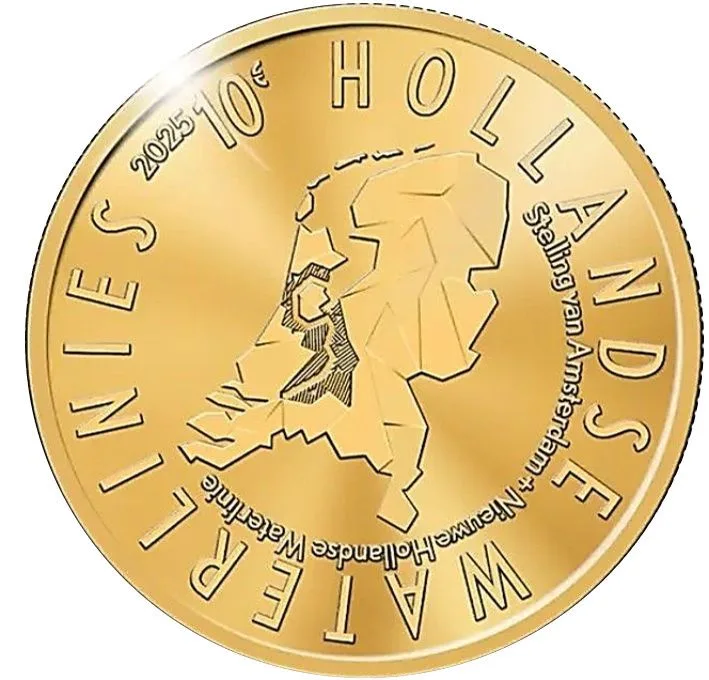
The gold “tientje” continues the tradition of the gold ten-guilder coins, but its design is unusual for it: instead of a portrait and arms, a map of the country reduced to planes and triangles. On the small gold disc such a scheme gains: crisp planes that read as a map on the larger coin turn into a jeweller’s pattern in which each plane catches the light in its own way. The line of the water frontiers looks like a fine golden thread and the triangles of the forts like a scatter of tiny marks. The metal that in the Dutch tradition means savings serves here to tell how the country defended its rich lands with water. For a collector it is an example of how contemporary graphics can be at home even on a classic gold coin.
Obverse
The story side is not a view of a structure but a sculptured map of the Netherlands that shows three things: land, water and military structures. The Dutch landscape is rendered in separate planes of different height — that is the land. Several planes are shaded — that marks the inundation areas, that is, the water. The line runs where the Dutch Water Defence Lines lie, and the triangles along it are the forts, fortresses and castles. The inscription “HOLLANDSE WATERLINIES 2025 5€” is supplemented by the line “Stelling van Amsterdam + Nieuwe Hollandse Waterlinie” (“Defence Line of Amsterdam + New Dutch Waterline”), which shows that the coin joins both parts of the property. The designer is Hans Gremmen, who had already shown seven hundred and fifty years of Amsterdam on a coin.
Reverse
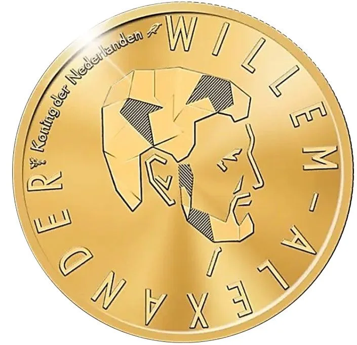
The official side shows a stylised profile of King Willem-Alexander facing right. Gremmen built it from the same elements as the map: planes of land, shaded water and triangles of structures. The element of water, as KNM explains, is needed for unity with the story side but also recalls the king’s role in water management, which he took up before his accession. Thus portrait and map read as one picture: the monarch is literally composed of the landscape that the water lines defended. The lettering is given in simple form — “WILLEM-ALEXANDER Koning der Nederlanden” (“Willem-Alexander, King of the Netherlands”), and the edge carries the usual “GOD * ZIJ * MET * ONS *” (“God be with us”).